Beschreibung
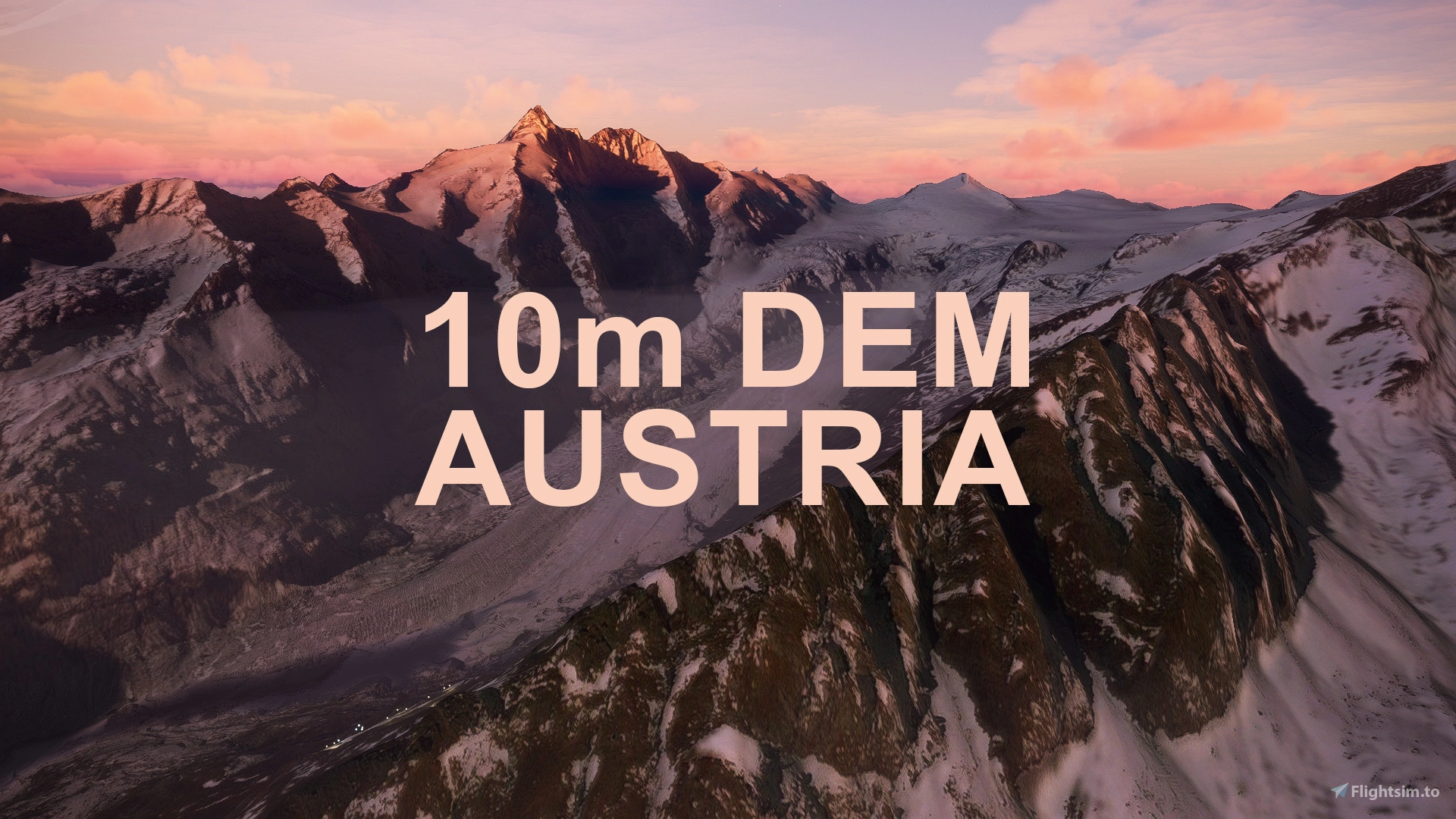
This mod contains customized height profiles for Austria in a 2 part download. The mod contains high definition LIDAR DEM data with a mesh resolution of 10m, whereas the MSFS uses a lateral resolution of about 50m or worse. The height resolution is as good as 0.1m.
The mod does not only provide mountain shapes being very close to reality, but also flattens lakes & rivers and gets rid of any terrain artifacts.
Everything has been split into several regions, due to both, convenience for the creator compiling it and performance on the users' end.
IMPORTANT
PLEASE MAKE SURE TO DOWNLOAD BOTH PARTS!
Disclaimer: The creator of this mod is not responsible for any problems, damage, incompatibilites to other mods or performance issues that might occur.
Please note, that this mod is a very high resolution mesh covering the whole of Austria. The elevation data is applied through terraforming rectangles, thus loaded at a certain distance from the player. When travelling fast or at high alitude (wide range of view) there might be too many new rectangles loaded simultaneously and thus stutters might occur.
If you have any stutters you can try and reduce your ingame render settings or switch to the lower resolution mod:
DOWNLOAD 20m DEM
If you are mainly flying airliners in high altitude, there is probably no benefit for you in using this mod.
As mentioned the mesh is split into regions/states of Austria. They can be activated at once or individually!
Area codes correspondence:
b - Burgenland
ooe - Upper Austria
noe1 - Lower Austria (west)
noe2 - Lower Austria (east) including Vienna
k - Carinthia/East Tyrol
s - Salzburg
st1 - Styria (west)
st2 - Styria (east)
t - Tyrol
v - Vorarlberg
I tested several sceneries to get an idea of the compatibility between high resolution mesh data and the airports.
Freeware
Tested several freeware airports, they were mostly fine except of a few floating buildings here and there.
Payware
All of the currently available Payware Airports should work fine, as fixes have been applied.
Credits
The elevation data used was a LIDAR 10m height profile of Austria, compiled by Sonny (https://data.opendataportal.at/dataset/dtm-austria/resource/7fd4a6c3-16b8-4632-9978-10344c404a69)
It was then transfered into MSFS using MSFS Toolkit by Nool Aerosystems (https://msfs.nool.ee/)
Thank you both and for anyone reading this: Please go ahead and support them!
Simply unzip the download and copy&paste the contained folders into your "community folder".
Enjoy your VFR flights above Austria!
Kommentare(351)
Melden Sie sich an, um an der Diskussion teilzunehmen
Anmeldenabout 1 year ago
Other than that, what a stunning release, this is just so far superior to the default elevation data, it feels like flying in the alps for real!
over 1 year ago
almost 2 years ago
over 2 years ago
Bin von Innsbruck LOWI mit der Ju52 im Tiefflug hinüber zum Starnberger See geflogen. Super Grafik.
NVIDIA RTX3080 ohne Ruckler alles flüssig dargestellt.
almost 3 years ago
ich musste dein AddOn leider wieder deaktivieren, weil mein Prozessor damit überfordert war. Bin mit einem Ryzen 7 7800X3D und einer Radeon 7900XT GPU zwar ganz gut aufgestellt, denke ich. Der MSFS läuft auch ruckelfrei in hoher Auflösung, wobei die Temperaturen der CPU bzw. GPU knapp unter 70° bleiben (kein Over-Clocking).
Aber wenn ich 10m DEM Austria aktiviere und z.B. in Graz an der 35R stehe, steigt meine CPU-Temperatur sofort sprunghaft auf >90°, sobald ich nur seitwärts aus dem Cockpit blicke.
Der Prozessor ist anscheinend intensivst mit irgendwelchen Berechnungen beschäftigt - obwohl die Auslastung nur knapp über 50% liegt. Der PC schaltet dann wegen Überhitzung ab...
Gruss ManAljo
almost 3 years ago
exakt! Das Mesh ist nicht gerade schonend für die CPU! Deshalb empfehle ich es nur, wenn man einen guten PC hat und sehr tief fliegt. Gerade für Airliner Flüge in größeren Höhen ist es sehr nachteilhaft. Große Bereiche des Meshes sind gleichzeitig im Blickfeld und müssen berechnet werden. Hier ist auch kaum ein visueller Vorteil zu Microsofts Standard-Mesh übrig.
over 2 years ago
over 3 years ago
Hi, hab eben deine Mod in Niederösterreich an verschiedenen Postionen probiert, aber leider keinen Unterschied zu Asobo festgestellt. Kann es sein dass Asobo bereits die Auflösung von 10m hat? Hab allerdings nur die .noe1+2 Folder in den Community Ordner kopiert.
over 3 years ago
Hallo, seit dem Österreich Update in MSFS ist praktisch kein Unterschied gegeben, in einigen Stellen ist Asobos Variante sogar besser.
Der Unterschied ist das verschiedenartige Rendern. Mit dieser Mod werden die Geometrien und Formen der Berge schon früher höher aufgelöst dargestellt und das sogenannte "morphing" (wenn die Bergform sich beim Annähern ständig ändert in der Auflösung) ist minimiert. Dafür kann diese Mod zu einigen Performanceproblemen auf PCs verursachen, die nicht High End sind.
Fazit: wenn man ganz viel VFR in den Tälern fliegt hat diese Mod einen Vorteil, wenn man nur mit Airlinern hoch oben fliegt, dann bitte nicht verwenden!
over 3 years ago
When i use your austria 10m DEM with ORBX Innsbruck, i get some veeery deep trench around innsbruck... the trench is moving forward when i fly over it.... when i am over the city i can look back and the height is broken around the airport.
almost 4 years ago
Not playable with a nvidia gtx 1080 graphics card, 32 GB DDR, and an Intel i7 7700k. It's a shame, there's definitely something here. But the processor is absolutely overloaded with it. First I activated all regions. MSFS capitulated. The second time, it worked. The pagefile was the same as my RAM! I'm smart (definitivly), so I deactivated the regions that are further away, as in the info.txt. But didn't bring anything. The processor was also overwhelmed by this. Well, so unfortunately I have to play without the addon, as much as I would like to! Thanks anyway!!!
over 3 years ago
there is a 20m resolution version maybe it will work with that one: https://de.flightsim.to/file/14818/austria-20m-dem-high-resolution-terrain-elevation-data-from-lidar-imaging
over 4 years ago
Hi, das DEM 2 Meter für die Kanarische Inseln läuft auch mit dem neusten Update ohne Probleme. Wurde hierfür eine andere Quelle benutzt?
over 4 years ago
Ich kenne das Addon leider nicht, aber ich vermute, dass die Höhendaten direkt implementiert wurden und nicht per Terraforming die eigentlichen Höhen überschreiben. Leider ist es einem Laien wie mir nicht möglich die Höhen so einzufügen. Ich hoffe, dass Microsoft wieder optimiert mit dem nächsten Update.
Ich persönlich habe nämlich wieder extrem viele Sim Crashes auch ganz ohne jegliche Addons.
over 4 years ago
Ich hab die dateien in mein Community folder wie üblich gepackt, MSFS gestartet, einen Flug gestartet und jetzt warte ich ungefähr 40 minuten auf dem Loading screen. Ist das normal das man so lange warten muss oder ist der Problem bei mir?
Alle deine andere DEMs funktionieren einwandfrei, nur hier gibt's den Problem.
over 4 years ago
Hallo, bitte die Mod aktuell nicht verwenden, da gibt es seit Sim Update 8 Probleme.
Ich arbeite an einer Lösung, habe aber leider noch keine parat.
Leider ermöglicht Flightsim.to es nicht den Download der Mod temporär auszuschalten, deshalb ist die mod noch online
about 4 years ago
Ich könnte das jetzt einzeln ausprobieren, aber vielleicht kannst du das selber direkt beantworten: Gilt das nur für den 10 Meter DEM von Österreich oder für alle deine DEM Projekte?
AUSTRIA 10m DEM - High Resolution Terrain Elevation Data from LIDAR Imaging
Explore the stunning terrain of Austria with this mod featuring high-resolution LIDAR data, offering a mesh resolution of 10m for a more realistic flight experience. Flatten lakes, rivers, and eliminate any terrain artifacts as you soar over the Austrian landscape. Divided into regions for convenience and performance optimization, this mod enhances the mountain shapes to mirror reality and provides a smoother flying experience. Experience Austria like never before with enhanced elevation data and realistic terrains.

Unterstützer
Nutzerbewertungen
56 Bewertungen
Location
More Information
Versionsgeschichte
Since World Update 6, the generic mesh data is really high quality. However, here is a short pro and con list for the use of this Addon: CON * Default mesh is now higher quality, when being very close to the ground/mountains PRO * The mountains still look better from far away, as the LOD scaling is very different. Default mountains get round at a certain distance * This mod does not cause "pop ins" of high quality when flying close to mountains. Changes v1.3: * Excluded photogrammetry areas of Vienna, Graz * Excluded LOWG Graz * Recompiled with new algorithm * Adjusted falloff distance for better blending with surrounding areas
Ähnliche Addons

Swiss mountains tree fix (trees on mountains removed)
A comprehensive mod fixing tree placement on Swiss mountains, particularly removing inaccurately placed trees on mountain peaks. The update includes a shift to more realistic conifer trees in the Alps and an expansion to border areas of France, Italy, and Austria. From Alpstein Säntis to Stockhorn, numerous locations across Switzerland have been meticulously corrected for a more authentic flight experience.
von THEOLI4D

Shorter Trees / Tree Height Modification VERSION 4.0 for MFS2020 (shorter, realistic trees)
Experience realistic and shorter trees in Microsoft Flight Simulator with the Shorter Trees / Tree Height Modification VERSION 4.0 add-on. Compatible with the latest version of MSFS, this mod provides adjusted tree heights for a more authentic flying experience. Update includes enhanced tree coloration blending seamlessly with photogrammetry trees. Installation is simple - just copy the folder into your community folder and enjoy a new perspective from the skies.
von ARIF STUDIOS - Adnan Arif

SWITZERLAND 20m DEM - High Resolution Terrain Elevation Data from LIDAR Imaging
Explore the beauty of Switzerland with this mod offering high resolution terrain elevation data using LIDAR imaging. The mesh resolution is 20m, providing exceptional detail with a height resolution of 0.1m. Update includes extreme LIDAR meshes for specific regions. Please note potential performance impacts and report any bugs for further improvements. Fly VFR over Switzerland with enhanced realism and accuracy.
von Troglodytus
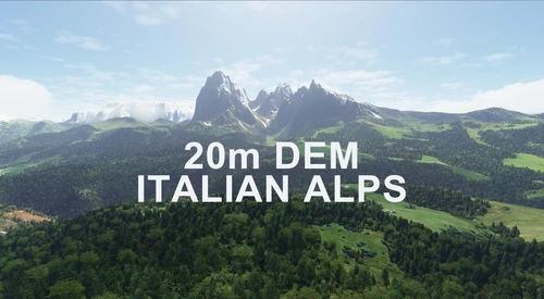
ITALIAN ALPS 20m DEM - High Resolution Terrain Elevation Data from LIDAR Imaging
Explore the beauty of the Italian Alps with this mod featuring high-resolution terrain elevation data obtained from LIDAR imaging. With a mesh resolution of 20m and a height resolution of 0.1m, this addon provides realistic mountain shapes, flattens lakes and rivers, and eliminates terrain artifacts. Please note potential performance issues related to loading distances when using this mod, especially in high-speed or high-altitude flights. Experience realistic scenery across the Alps and enjoy your VFR flights above Italy!
von Troglodytus
2 months ago