Beschreibung
DEVELOPMENT DISCONTINUED
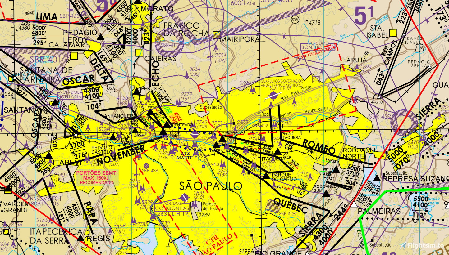
Flying VFR under controlled airspace in Brazil can be hard - it is mandatory to follow very specific corridors and report at given VFR positions, which are defined by geographic features. This add-on places standard FS Landmarks over these positions, making the process of familiarization with the routes much easier.
Compiled by me with kind permission of Fábio Miguel and the X-Plane Brazilian community.
Standard add-on packaging and installation process.
Version 1.6 was recompiled from scratch from source. Unfortunately, there is a bug introduced in MSFS Sim Update 5 which makes it necessary to specify a landmark's altitude. As a temporary workaround, some positions will be displayed floating around 1000ft AGL.
CAVEATS (due to MSFS limitations):
- Landmarks are only displayed within a radius of around 5.5km (MSFS limitation, as of SU5);
- Only one label is displayed at once (but more than one pin is visible at a time), however, this can be changed within MSFS settings.
Kommentare(35)
Melden Sie sich an, um an der Diskussion teilzunehmen
Anmeldenover 1 year ago
By any chance, would you happen to have the raw file with every coordinate of the POIs? I'm trying to create the .csv file for the PMS GTN750 and it's giving me a hard time, since I have to manually look for each coordinate in the charts. If you do, let me know please. I will be happy to share the result after it's done.
Best regards
over 2 years ago
ou aonde eu acho as coordenadas de cada posicão?
Obrigado!
about 2 years ago
almost 3 years ago
over 4 years ago
Existe algum modo de colocar esses "pontos" diretamente de dentro do avião? Só consigo planejar o vôo com os pontos antes de carregar o avião no chão.
Mas por enquanto está perfeito mesmo assim! Muito obrigado pelo trabalho!
over 4 years ago
Não sei se entendi bem sua pergunta, mas acho que você se refere a colocar as posições no plano de voo/GPS. Infelizmente não é possível, pois são POIs (pontos de interesse) e não fixos. Os fixos têm o identificador limitado a 5 caracteres e só apareceriam no mapa, além de ficarem misturados com os fixos reais IFR. O jeito é voar na mão mesmo (até porque a regra não é seguir o eixo do corredor e sim manter-se à direita, hehe).
almost 5 years ago
Muito obrigado!
almost 5 years ago
Você pode adicionar as posições da VAC de SBPJ em uma nova versão, por gentileza? A carta está disponível no AISWEB, ou se preferir, vou te passar as posições:
AGROTINS: 10 23 50.17 S 048 22 16.82 W;
FERROVIA: 10 12 34.54 S 048 33 10.19 W;
GRACIOSA: 10 11 18.54 S 048 21 54.08 W;
CESAMAR: 10 12 32.77 S 048 19 20.35 W;
TAQUARALTO: 10 20 01.14 S 048 17 47.75 W
almost 5 years ago
Opa, já que você me passou as coordenadas formatadas direitinho fica fácil. Assim que possível farei!
almost 5 years ago
vlw, meu querido!
almost 5 years ago
Colocou as posições de SBPJ nas novas atualizações! 😍
almost 5 years ago
Oi, ainda não. Na verdade estou bem enrolado, teve toda a mudança nas REA SP-RJ e em cima de tudo isso a última atualização do FS quebrou a maneira como as posições são exibidas, agora tem que especificar a altitude exata, então muitas estão ou flutuando ou debaixo do chão. Então vai dar um trabalhão pra arrumar tudo, e no momento o desenvolvimento deste projeto compete diretamente com meu trabalho, que é minha única fonte de renda.
Ah, lembrei de uma coisa: eu tinha procurado no AISWEB e não encontrei nem carta nem AIC sobre essas posições, você tem alguma informação a mais?
Obrigado!
almost 5 years ago
Tranquilo! Essas posições estão na VAC de SBPJ. Na página 2 da VAC tem as coordenadas, se não me engano.
almost 5 years ago
Ah, beleza. Vou dar uma conferida assim que tiver um tempinho livre!
about 5 years ago
Brazil VFR REA waypoints as landmarks
Enhance your VFR flying experience in Brazil with this add-on featuring FS Landmarks at mandatory VFR positions. Developed to assist in navigating specific corridors under controlled airspace, this tool offers valuable geographic references to aid in route familiarization. Note that due to MSFS limitations, landmarks may display at a temporary altitude due to a bug introduced in Sim Update 5. Discover Brazils VFR waypoints as landmarks within a 5.5km radius, with the option to customize display settings within MSFS.

Nutzerbewertungen
5 Bewertungen
Location
More Information
Versionsgeschichte
Further improvements to position elevations.
Ähnliche Addons
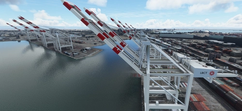
San Pedro Bay Port Facilities, Los Angeles & Long Beach CA USA (V3.0 MSFS2020) / (V1.3 MSFS2024)
This add-on provides detailed scenery enhancements for the San Pedro Bay port facilities in Los Angeles and Long Beach, California, specifically optimized for both MSFS2020 and MSFS2024. Version 3.0 for MSFS2020 features improved models, with significant updates including new cargo crane designs and streamlined asset management. The MSFS2024 version introduces additional upgrades and new details while ensuring compatibility with the latest simulator features.
von FreakyD
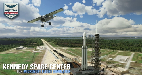
Kennedy Space Center
Explore the iconic Kennedy Space Center in Microsoft Flight Simulator with this detailed add-on, featuring key landmarks such as the VAB Building, Launch Control Building, and Launch Complexes 39A & 39B. Witness the impressive Falcon Heavy Rocket and SpaceX Rocket Assembly building as you embark on virtual space missions. Additional updates promise more buildings and assets to enhance your experience.
von Acktu
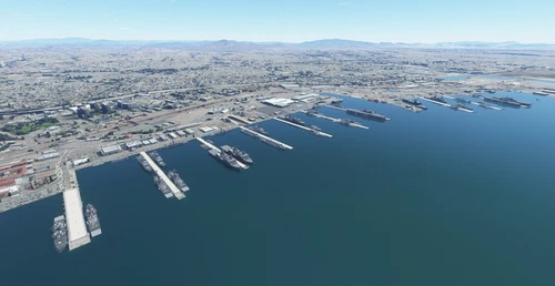
US Navy - San Diego V3.0.1
The US Navy - San Diego V3.0.1 add-on enhances the naval scenery around San Diego in Microsoft Flight Simulator. It includes a variety of updated ship models and improved textures, ensuring compatibility with both MSFS2020 and MSFS2024. Key features include detailed representations of the Rosecrans Submarine Base, multiple naval shipyards, and various classes of ships, including attack submarines and aircraft carriers. Recent updates have focused on model clean-up and the addition of interactive landing pads for helicopters.
von FreakyD

HungaryVFR FS2020
HungaryVFR is a package covering Hungary with airports and landmark sceneries, with its own library. The main goal is to bring as many airports and landmarks to Hungary as many we can, to have an authentic library for the are. The library can be used by other 3rd party scenery developers!
von ekre
4 months ago