Flightsim.to
    PilotPathRecorder - Image 1

    Beschreibung

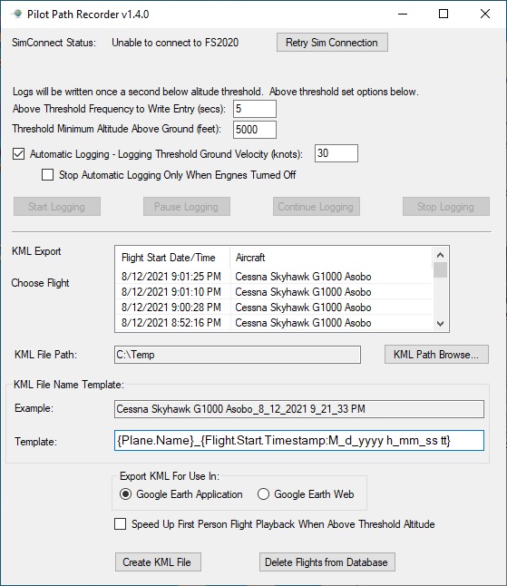
    PilotPathRecorder is a replay and flight data capture tool that allows you to see your flight information visually using Google Earth. Simply use the application to log your flight and export that data to a KML file. That file can then be used with Google Earth for 3-dimensional flight analysis, flight plan information, and a chance to replay your flight from the first-person perspective.  Detailed information is also available throughout your flight, such as speed, altitude, flap position, engine rpm, pitch, roll temperature, wind, flaps, lights, and much more.

    This is a stand-alone application that is run outside of Microsft Flight Simulator 2020. Once run, this application allows the user to set various settings to control the recording and exporting experience. A database is used to store your flights so feel free to fly during one session and export in another.

    Installation is easy.  Unzip to any location you wish.  Once unzipped, launch Flight Simulator and then the FS2020PlanePath.exe to start the application.

    More detailed information can be found at: https://github.com/SAHorowitz/MSFS2020-PilotPathRecorder/blob/master/README.md

    Kommentare(11)

    Melden Sie sich an, um an der Diskussion teilzunehmen

    Anmelden
    P

    over 1 year ago

    Easy to use and to change the description of the route.
    O

    about 4 years ago

    Welcome and good day!Today my fundamental way of thinking is:Most essential logbook - features are:Pilot in command + airplane/type + dep.airport + flight route/course + dest.airport + date/timeNot coincidentally - PilotPathRecorder has axactly the basic properties of input/output requests.I have tested PilotPathRecorder during several ( 8 ) flights - flight duration 1 hour up to 3 hours (A320 FBW - DEV_mod)Benifits/absolute advantage:- no computing power needed ( CPU < 1% )- minimal memory/storage space ( e.g. LFTM to OLBA  ca,1000 km = 2200 kb ) [ KB - not MB, - not GB]- easy to share it with (non flightsim) friends (e.g. Google Earth™ )- no / never CTDMy way to use PilotPathRecorder is:I start PilotPathRecorder at first (before msfs2020) --> minimize it --> and forget it till flight session ended (or PC powering down)PilotPathRecorder knows exact(ly) start and end of working/recording timeI have tested/tried ( 4 ) well known/most famous recorder(s)Issues/troubles:- computing power CPU/GPU (above msfs2020)- - e.g. due to parallel (twice) running world map- memory/storage space - no chance to share it with (non flightsim) friends- CTD sometimes (flight time > 1 hour)Dear community - Good day to youWith best regards from AUSTRIAOE_TBMIch bin ein Innviertler - die mögen keinenFirlefanz (überflüssiges oder wertloses Zeug) !
    j

    about 5 years ago

    I have to test it soon, thanks!
    t

    about 5 years ago

    Is the opposite possible? I have some real life google earth logs from flights over the years, can these be imported to get the sim to recreate the flights?
    J

    about 5 years ago

    Perhaps my converter can help you: ConvertKml2Pgt.
    You find it at flightsim.to.
    It is designed to import a SkyDemo KML-File to PGT, which can be used with "FS Playground" to replay your real flight.
    t

    about 5 years ago

    Awesome thanks. I'll check it out!
    F

    over 5 years ago

    This is a great tool! It makes it easy to keep track of my flights in Google Earth. It is very motivational to look at my globe; it makes me want to go new places. Thank you!
    j

    about 5 years ago

    yep , fully agree with you.
    p

    over 5 years ago

    Worked perfectly! Flew a small loop and brought the KML file up in google earth, nice!
    s

    over 5 years ago

    I downloaded this via Reddit some months ago - delighted to see it here. It's a fantastic piece of software. Thank you and well done!
    L

    over 5 years ago

    This is exactly what I needed, I am traveling around the world and after each session I had to manually create a path in Google Earth, now I hope this will save me some time! Thx!
    MSFS 2020MSFS 2024

    PilotPathRecorder

    "PilotPathRecorder is a replay and flight data capture tool that visualizes your flight information using Google Earth. Log your flight, export the data to a KML file, and analyze your flight in 3D, including speed, altitude, engine data, wind, and more. This stand-alone application is easy to install and allows customization of recording settings for a detailed flight analysis experience."

    Downloads1K
    Version1.4.1
    Dateigröße4.12 MB
    VeröffentlichtVor 5 Jahren
    AktualisiertVor 4 Jahren

    Nutzerbewertungen

    5.0

    5 Bewertungen

    5
    100%
    4
    0%
    3
    0%
    2
    0%
    1
    0%

    More Information

    Simulator
    MSFS2020
    KategorieUtilities
    Sub-CategoryApplications

    Versionsgeschichte

    - Fixed issue with waypoints causing an exception if they have a zero altitude. This would cause the SimConnect to disconnect. - Rewrote AddWaypoint algorithm to make it much simpler and easier to understand - Added logger for general exceptions that would cause SimConnect to disconnect. This will make finding future issues easier.