
Beschreibung
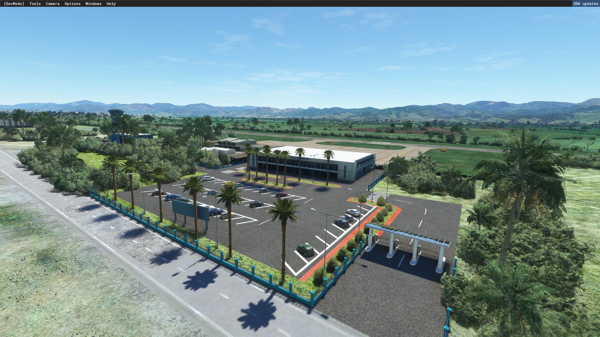
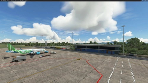
Dien Bien Airport (IATA: DIN, ICAO: VVDB) (Vietnamese: Sân bay Điện Biên) is located at Điện Biên Phủ in Vietnam.
History[edit]
Điện Biên Phủ Airport was established in 1954 as Mường Thanh Airfield. The main purpose of it is to serve the French HQ in Điện Biên Phủ at the time of the First Indochina War.
4 years after the French left Điện Biên Phủ, in 1958, commercial flights to the airport started, operated by the Air Force, but only for a while due to the low demand at the time. In 1984, along with the 30th Anniversary of the Battle of Dien Bien Phu, flights from Hanoi to Điện Biên Phủ resumed, operated by the Antonov An-24. 10 months later, in January 30, 1995, this route is once again suspended because of the runway needed to be repaired. After the repair, flight resumed, this time being operated by the ATR 72. In 2004, the airport's apron is extended to 12000 square meters, with 4 parking stands for ATR 72 aircraft.
Facilities[edit]
Today, Điện Biên Phủ Airport is the largest and only commercial airport serving the city of Điện Biên Phủ in particular and the entire Northwest region of Vietnam, after the closure of Nà Sản Airport in 2004. It is located in the middle of a basin at an altitude of 1.611 meters above sea level. The sole runway (16/34) has a concrete surface and a length 1830 meters (6003 ft) long and width of 30 m (98.4 ft), large enough to accommodate aircraft such as the ATR 72 or the Fokker F70 and potentially the Embraer E190 and E195 with some payload restrictions as demonstrated by Bamboo Airways' use of the jets at Con Dao Airport, which has a similar-length runway.
The apron and taxiway is 7500 square meters wide, with 4 parking stands for aircraft. The terminal is 2500 square meters wide and is capable of serving 4 flights per day. The airport is being upgraded with a new 2,400 metres (7,900 ft) × 45 metres (148 ft) runway and associated facilities to make it compatible with bigger-sized narrow-body airliners such as the Airbus A320/A321 and Boeing 737.[2]
Challenges[edit]
Due to its geographical position, the airport's runway cannot be extended to serve larger aircraft such as the Airbus A320 family, Boeing 737 and similar. The installation of night lights and modern guidance systems is also not possible due to the atmospheric and weather conditions at the airport, render it only capable of serving daytime flights. Also, the cancel rate of flights to Dien Bien Phu is also higher than other routes, due to the unpredictable and inclement nature of the weather at the airport.
And due to its short runway and the aircraft type serving it, the airport can only serve short-haul routes, such as Hanoi- Dien Bien Phu or Hai Phong-Dien Bien Phu.
Expansion[edit]
Dien Bien province People's Committee has approved the temporary closure of the airport following an expansion proposal by the Civil Aviation Authority of Vietnam. The closure will start from 1 April 2023 and lasts 6 months. The expansion includes building a new security fences, upgrading terminal's facilities and the lengthening and widening of the runway.
The runway will be extended to 2400 m (7874 ft) and widened to 45 m, enabling the airport to accommodate A320/A321 or equivalent aircraft. The terminal will be upgraded to receive up to 500 thousand passengers per year. On 30 November 2023, the expansion project was completed and the airport will resume all operations on 2 December.[1]
The project cost is estimated to be around VND 1.467 trillion (US$ 62 million), all paid for by ACV.[3][4]
(Wikipedia)
Location
Dien Bien Airport - VVDB
Điện Biên Phủ Airport was established in 1954 as Mường Thanh Airfield. The main purpose of it is to serve the French HQ in Điện Biên Phủ at the time of the First Indochina War. 4 years after the French left Điện Biên Phủ, in 1958, commercial flights to the airport started, operated by the Air Force, but only for a while due to the low demand at the time. In 1984, along with the 30th Anniversary of the Battle of Dien Bien Phu, flights from Hanoi to Điện Biên Phủ resumed, operated by the Antonov An-24. 10 months later, in January 30, 1995, this route is once again suspended because of the runway needed to be repaired. After the repair, flight resumed, this time being operated by the ATR 72. In 2004, the airport's apron is extended to 12000 square meters, with 4 parking stands for ATR 72 aircraft.


Mitwirkende

Nutzerbewertungen
3 Bewertungen
Versionsgeschichte
Redraw apron Redraw runway marking
Ähnliche Addons
Lien Khuong Airport - VVDL
Lien Khuong Airport (IATA: DLI, ICAO: VVDL) (Vietnamese: Cảng hàng không Liên Khương) is an international airport located in Đức Trọng District, about 30 km south of Da Lat, Lâm Đồng Province. It is the largest among 4 airports in the Central Highlands region of Vietnam. The major reconstruction in order to handle bigger aircraft was completed in December 2009. This airport handled 1,690,000 passengers in 2019, an increase of 18.3% against that of 2014
von gaukon9
Phu Bai Airport - VVPB
Explore Phu Bai International Airport (IATA: HUI, ICAO: VVPB) located near the historical city of Huế, Vietnam. Discover the airports history and future developments, including recent runway repairs and upgrades, and the construction of a new terminal to accommodate millions of passengers annually.
von gaukon9
Côn Đảo Airport - VVCS
Explore Côn Đảo Airport (VVCS) on Côn Sơn Island in Vietnam with this add-on. Enhancements include fixes to the default airport, though note that there are no runway lights for night flying. Additionally, a separate library is required to see 3D people on the beach. Experience this unique destination from 6am to 6pm local time.
von gaukon9
Dong Hoi Airport - VVDH
Experience the charm of Dong Hoi Airport (IATA: VDH, ICAO: VVDH) in Vietnam, located conveniently just north of Đồng Hới city and by the South China Sea. Originally built in the 1930s and upgraded over the years, this airport now serves as an important hub in the North Central Coast region, with plans for further expansion to accommodate larger aircraft and increased passenger capacity.
von gaukon9
Melden Sie sich an, um an der Diskussion teilzunehmen
AnmeldenKommentare(13)
12 months ago
10 months ago
over 2 years ago
over 2 years ago
almost 3 years ago
how to install? please provide us! a tutorial
almost 3 years ago
almost 3 years ago
about 3 years ago
about 3 years ago
almost 4 years ago
Thêm cả đèn luôn, hay quá.
about 4 years ago
toẹt zời
about 4 years ago
thanks mate . KenPham :D
about 4 years ago
down bản update để GSX hoạt động nha a :))