Beschreibung
Version 1.1
Minor fix to try and improve the Conwy bridge height if using this mod with skell300's great North Wales POI's
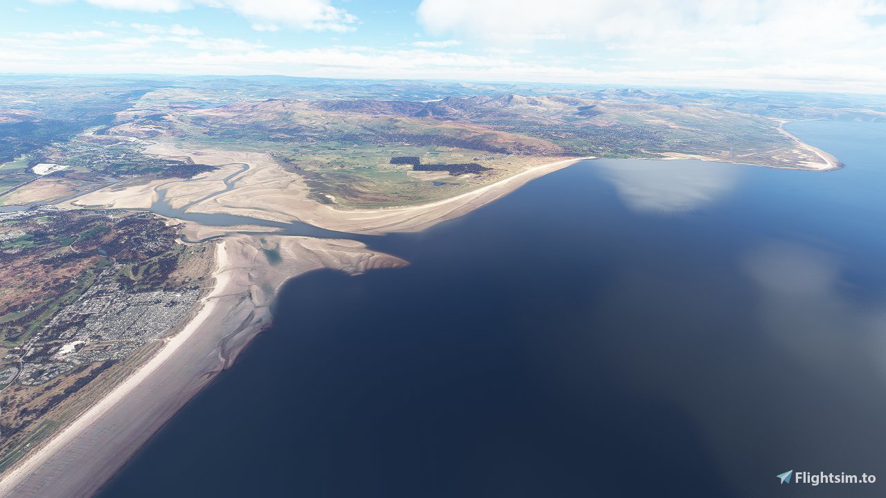
This is the 3rd addition of my scenery mod to uncover the Sandbanks which covers the North Wales coast from Rhyl, Conwy, around Angelsey, and down to Aberdyfi.
Please note this is not perfect yet and may be updated further but currently shows a nice representation of the sandbanks at low tide where the Bing maps imagery allows.
Screeenshots are taken with ORBX Great Britain Central installed but this mod should work fine if you dont have ORBX.
For installation extract the included folder called " North Wales Sandbanks" into your MSFS Community folder.
Check out my other sandbank mods here: https://flightsim.to/profile/mgk07/uploads
Thanks,
Mark.
Kommentare(10)
Melden Sie sich an, um an der Diskussion teilzunehmen
Anmeldenabout 4 years ago
Thanks for this, a great addition, much appreciated.
over 4 years ago
This mod completes the north of Wales when combined with the excellent North Wales Landmarks and local freeware airfields (EGCK, EGOV, EGNR). Low tide never looks so good! Very, very highly recommended!
over 4 years ago
Fantastic work! Can you do similar magic with the Ayrshire coastline?
over 4 years ago
Thank you. I’m sure I’ll take a look at some point. Will add it to the list.
over 4 years ago
Great work, I was flying around EGOV the other day and the sandbanks there looked absolutely spectacular. I'd say I spent more time looking at them than I did flying! If you're taking requests, I'd love to see what you could do around Cork Harbour, Ireland!
over 4 years ago
Thanks! Glad you like it. I’ll add Cork Harbour to the list and see what’s possible there.
over 4 years ago
Very nice, as are the other two. They make the coastlines look so much more realistic. Thank you.
North Wales Sandbanks
Discover the picturesque Sandbanks along the North Wales coast from Rhyl to Aberdyfi with this scenery mod. Version 1.1 includes minor fixes and offers a nice representation of the sandbanks at low tide, designed using Bing maps imagery. Installation is easy - just extract the folder into your MSFS Community folder.

Nutzerbewertungen
6 Bewertungen
Location
More Information
Versionsgeschichte
Version 1.1 Minor fix to try and improve the Conwy bridge height if using this mod with skell300's great North Wales POI's
Ähnliche Addons

Swiss mountains tree fix (trees on mountains removed)
A comprehensive mod fixing tree placement on Swiss mountains, particularly removing inaccurately placed trees on mountain peaks. The update includes a shift to more realistic conifer trees in the Alps and an expansion to border areas of France, Italy, and Austria. From Alpstein Säntis to Stockhorn, numerous locations across Switzerland have been meticulously corrected for a more authentic flight experience.
von THEOLI4D

Shorter Trees / Tree Height Modification VERSION 4.0 for MFS2020 (shorter, realistic trees)
Experience realistic and shorter trees in Microsoft Flight Simulator with the Shorter Trees / Tree Height Modification VERSION 4.0 add-on. Compatible with the latest version of MSFS, this mod provides adjusted tree heights for a more authentic flying experience. Update includes enhanced tree coloration blending seamlessly with photogrammetry trees. Installation is simple - just copy the folder into your community folder and enjoy a new perspective from the skies.
von ARIF STUDIOS - Adnan Arif

AUSTRIA 10m DEM - High Resolution Terrain Elevation Data from LIDAR Imaging
Explore the stunning terrain of Austria with this mod featuring high-resolution LIDAR data, offering a mesh resolution of 10m for a more realistic flight experience. Flatten lakes, rivers, and eliminate any terrain artifacts as you soar over the Austrian landscape. Divided into regions for convenience and performance optimization, this mod enhances the mountain shapes to mirror reality and provides a smoother flying experience. Experience Austria like never before with enhanced elevation data and realistic terrains.
von Troglodytus

SWITZERLAND 20m DEM - High Resolution Terrain Elevation Data from LIDAR Imaging
Explore the beauty of Switzerland with this mod offering high resolution terrain elevation data using LIDAR imaging. The mesh resolution is 20m, providing exceptional detail with a height resolution of 0.1m. Update includes extreme LIDAR meshes for specific regions. Please note potential performance impacts and report any bugs for further improvements. Fly VFR over Switzerland with enhanced realism and accuracy.
von Troglodytus
about 2 years ago