Beschreibung
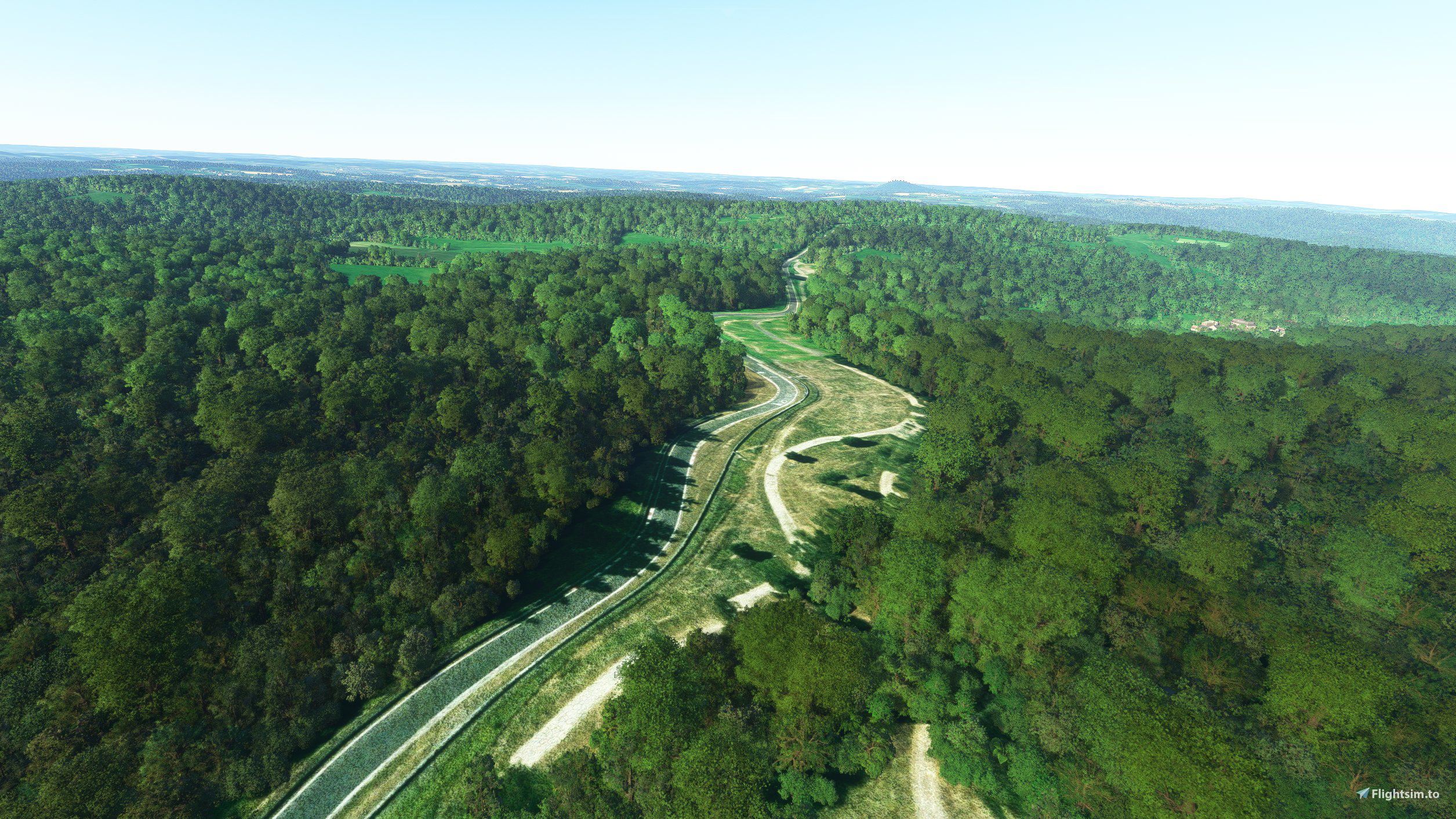
This addon removes trees and objects on the famous Nordschleife track.
You can now do laps around the track without hitting trees !
Nürburgring location : 50.338445026113156, 6.9499774702005155
INSTALLATION:
Unzip the archive in your Community folder
Kommentare(10)
Melden Sie sich an, um an der Diskussion teilzunehmen
Anmeldenover 4 years ago
nice, do you plan on adding custom models to the track? like pit buildings? the famous carpark etc?
over 4 years ago
That is indeed the first iteration and I'd like to improve it more (GP circuit and the Nordschleife). Custom models is part of the plan ;)
over 4 years ago
great, in that case, I look forward to seeing how it progresses.
over 4 years ago
Thank you.
over 4 years ago
Very nice work. Thanks.
Could you add a POI so it's easier to find on the map?
over 4 years ago
I'm glad you like it ! It is indeed a great idea ! I'll add it in the next update ;)
over 4 years ago
perfect. Thanks
over 4 years ago
THANKS FOR THIS GREAT MOD
over 4 years ago
Great idea!!! Can't wait to download this and run crazy laps!
Nürburgring Nordschleife Enhanced
Enhance your Nürburgring Nordschleife experience by removing trees and objects from the track, allowing for smoother laps. Simply unzip the archive in your Community folder to enjoy a tree-free racing experience at the iconic Nürburgring location.

Nutzerbewertungen
3 Bewertungen
Location
More Information
Versionsgeschichte
Added a Point Of Interest to locate the Nürburgring easily
Ähnliche Addons

Swiss mountains tree fix (trees on mountains removed)
A comprehensive mod fixing tree placement on Swiss mountains, particularly removing inaccurately placed trees on mountain peaks. The update includes a shift to more realistic conifer trees in the Alps and an expansion to border areas of France, Italy, and Austria. From Alpstein Säntis to Stockhorn, numerous locations across Switzerland have been meticulously corrected for a more authentic flight experience.
von THEOLI4D

Shorter Trees / Tree Height Modification VERSION 4.0 for MFS2020 (shorter, realistic trees)
Experience realistic and shorter trees in Microsoft Flight Simulator with the Shorter Trees / Tree Height Modification VERSION 4.0 add-on. Compatible with the latest version of MSFS, this mod provides adjusted tree heights for a more authentic flying experience. Update includes enhanced tree coloration blending seamlessly with photogrammetry trees. Installation is simple - just copy the folder into your community folder and enjoy a new perspective from the skies.
von ARIF STUDIOS - Adnan Arif

AUSTRIA 10m DEM - High Resolution Terrain Elevation Data from LIDAR Imaging
Explore the stunning terrain of Austria with this mod featuring high-resolution LIDAR data, offering a mesh resolution of 10m for a more realistic flight experience. Flatten lakes, rivers, and eliminate any terrain artifacts as you soar over the Austrian landscape. Divided into regions for convenience and performance optimization, this mod enhances the mountain shapes to mirror reality and provides a smoother flying experience. Experience Austria like never before with enhanced elevation data and realistic terrains.
von Troglodytus

SWITZERLAND 20m DEM - High Resolution Terrain Elevation Data from LIDAR Imaging
Explore the beauty of Switzerland with this mod offering high resolution terrain elevation data using LIDAR imaging. The mesh resolution is 20m, providing exceptional detail with a height resolution of 0.1m. Update includes extreme LIDAR meshes for specific regions. Please note potential performance impacts and report any bugs for further improvements. Fly VFR over Switzerland with enhanced realism and accuracy.
von Troglodytus
over 4 years ago
Großartig umgesetzt, die Nürburg fehlt noch.