Beschreibung
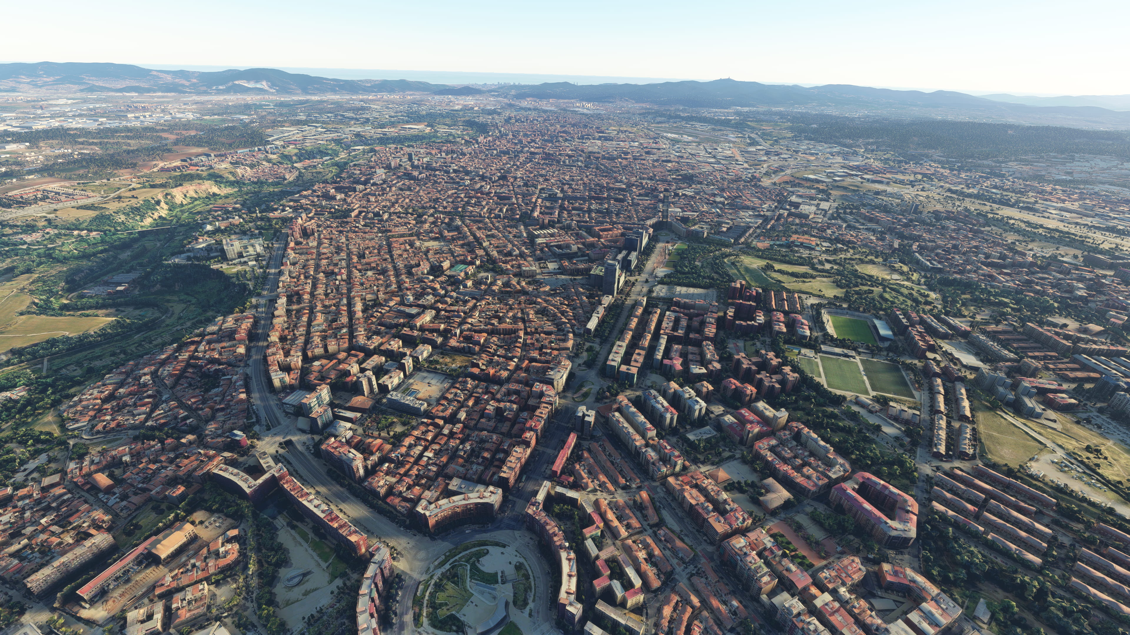
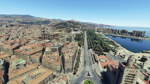
Sabadell city and LELL area based on Google Maps photogrammetry
Compatible with Sabadell Airport LELL by Footage Designs
Install
Download and unzip on Community folder
Credits
Jonahex111 (Goolge Earth Decoder)
thalixte (Optimization tool for Google Earth Decoder)
Google Maps
Kommentare(13)
Melden Sie sich an, um an der Diskussion teilzunehmen
Anmeldenover 4 years ago
Merci beaucoup!! :)
over 4 years ago
Hola, muchas gracias una vez mas por tus fabulosos escenarios. Pero tengo un problema con esta actualización, pues no se me refleja en el simulador. Si bien la primera versión me iba de lujo esta no tengo cojones. He borrado la anterior, y colocado esta, sin mas. Pero nada. He probado incluso añadiendo uno de esos archivos de los tres que suelen tener todos tus escenarios en la carpeta raiz, porque he visto que todos llevan tres y este dos, Y he copiado el que le faltaba de otro escenario pero nada....descargo de nuevo y pruebo, a ver si hubiera suerte...Saludos!!!
over 4 years ago
Hola, no se que puede pasar. Acabo de descargarlo por ver si había algún problema con el archivo y me funciona sin problema.
over 4 years ago
Gracias Ezro, el caso que es el unico que no me funciona...todos los demas van como la seda,,,me pondre mas en serio a ver que puede pasar. Me permito estas lineas para ver si puedes hacer Rincon de la Victoria en Malaga, que tiene fotogrametria...muuchas gracias!!!!!!
over 4 years ago
Todo lo que haces está genial. Un trabajo excelente.
over 4 years ago
Fantastic work, thank you very much Erzo! The same surrounding photogrametry scenery around Cuatro Vientos airfield, compatible with the Avaldesign scenery, would be fantastic!
over 4 years ago
Thanks! I like the idea of Cuatro Vientos, I might give it a try
over 4 years ago
Thanks a lot!! I´m sure that your approach scenery would be widely used by spanish community, because you are a wizard of color and FPS optimization . In addition, the people who did LECU for free deserve the best, their airport is extraordinary, very detailed, and they´re expanding the project to the military zone to leave the entire site completed.
over 4 years ago
I love all of your work! I have it all!
over 4 years ago
¿Es compatible con el aeropuerto de Sabadel que hay de pago?
over 4 years ago
Hola. Es compatible, por lo que he visto funciona bien. Eso sí, en los próximos días sacaré una pequeña actualización para eliminar algunos edificios de la fotogrametría que he visto que se cuelan en el aeropuerto. Saludos
over 4 years ago
Gracias!
Sabadell, Cataluña, Spain (LELL photogrammetry approach)
Explore the photogrammetry of Sabadell, Cataluña, Spain, including the LELL area, based on Google Maps data. This add-on is designed to be compatible with Sabadell Airport LELL by Footage Designs. Simply download and unzip the files into your Community folder to enjoy this detailed recreation.

Nutzerbewertungen
3 Bewertungen
Location
More Information
Versionsgeschichte
- Removed photogrammetry buildings that were bleeding through the airport ground (hangars and tower) - Improved compatibilty with LELL by Footage Designs. Some weird terrain elevations near runway 31 are now removed. - Improved airport surrounding area - More detail on Parc Taulí helipad
Ähnliche Addons
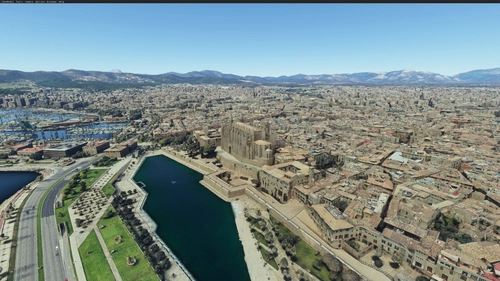
Palma de Mallorca, Islas Baleares, Spain
Explore Palma de Mallorca and its surrounding areas with this Microsoft Flight Simulator add-on, featuring high-detail photogrammetry based on Google Maps. Choose between a Full version with intricate textures or a Lite version for a simplified experience, suitable for less powerful machines. Despite some minor limitations in certain areas, this scenery offers a captivating upgrade from the MSFS default landscape.
von ezro
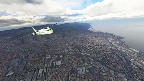
Santa Cruz de Tenerife (GCXO photogrammetry approach and La Laguna), Islas Canarias, Spain
Explore Santa Cruz de Tenerife in Microsoft Flight Simulator with this photogrammetry scenery add-on including La Laguna and GCXO Tenerife Norte approach. Updated for February 2023, it is compatible with World Update 8 Iberia and various airport add-ons. Discover more photogrammetry packages covering Tenerife for an immersive flying experience.
von ezro
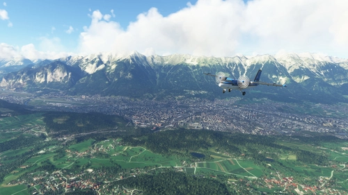
Innsbruck City / LOWI Approach, Austria (ORBX LOWI Compatible)
Experience Innsbruck city and LOWI Approach like never before with this add-on based on Google Maps photogrammetry. Compatible with ORBX LOWI Airport, this scenery brings stunning detail to your simulator. Simply download, unzip, and enjoy a realistic and immersive flight experience. Credits to Jonahex111, thalixte, and Google Maps for their contributions to this impressive add-on.
von ezro
Malaga, Andalucia, Spain (including nearby Torremolinos and Benalmadena)
Explore the stunning photogrammetry scenery of Malaga, Torremolinos, and Benalmadena in Spain, meticulously recreated based on Google Maps. Ensure proper installation by downloading and unzipping both files in the same folder. Please note some minor discrepancies with default scenery. Credits to Jonahex111, thalixte, and Google Maps for their contributions.
von ezro
over 2 years ago