Beschreibung
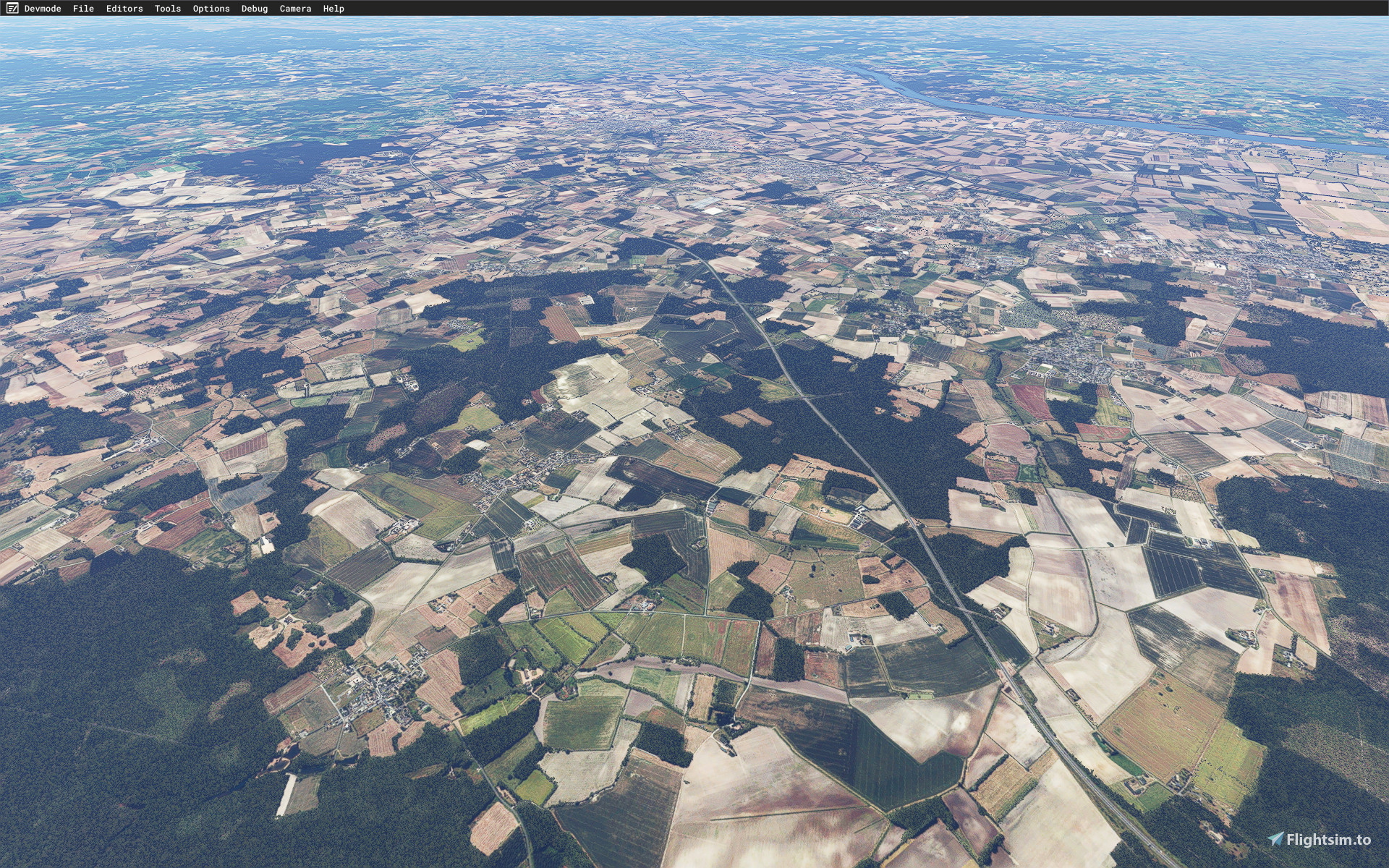
LFJR - ANGERS/Marcé - Aerial 1M - East Maine-et-Loire - 01
Aerial 1 meter resolution (LOD 17) for the eastern part of the Maine-et-Loire department suffering from the BingMap texture shift.
Source: BD, ORTHO®, OpenData, IGN.
Removed auto-generated houses on the offset BingMap map.
Removed the native vegetation on the offset BingMap texture and replaced it with vegetation polygons from the TOPO® OpenData IGN database.
Colorometric correction for better integration with ANGERS of the City update II.
Optional for LFJR - ANGERS/Marcé - Airport.
Thanks to:
Microsoft Asobo
Arno Gerretsen
MSFS Toolkit by Nool Aerosystems
Copyright: ftsxlw ftsx.free.lw@gmail.com
Exclusively for free distribution and subject to the express permission of the author.
============================================================================================================================================================================================================================================
LFJR - ANGERS/Marcé - Aerial 1M - East Maine-et-Loire - 01
Aerial 1 mètre de résolution (LOD 17) pour la partie Est du département du Maine-et-Loire souffrant du décalage de la texture BingMap.
Source BD ORTHO® OpenData IGN.
Suppression des maisons auto générées sur la texture BingMap décalée.
Suppression de la végétation native sur la texture BingMap décalée et remplacement par les polygones de végétations issues de la BD TOPO® OpenData IGN.
Correction colorométrique pour une meilleure intégration avec ANGERS de la City update II.
Optionnel pour LFJR - ANGERS/Marcé - Airport.
Merci à :
Microsoft
Asobo
Arno Gerretsen
MSFS Toolkit by Nool Aerosystems
Copyright : ftsxlw
ftsx.free.lw@gmail.com
Exclusivement pour diffusion gratuite et soumise à autorisation expresse de l’auteur.
Kommentare(5)
Melden Sie sich an, um an der Diskussion teilzunehmen
Anmeldenover 4 years ago
perso pas moi, grand merci aux auteurs
almost 5 years ago
Thanks for the scenery.
All of Part01 unzipped OK but I have a problem with Part02
When unzipping I get stuck as it looks for france-dpt-49-ftslw-lfjr-aerial-1m-0.9.6.part4.rar but there is no such file to download.
Am I perhaps too early and the file is still being uploaded?
almost 5 years ago
almost 5 years ago
Thanks for the reply.
I have downloaded the extra files I did not see yesterday and all unzipped just fine.
Sorry for the inconvenience.
LFJR - ANGERS/Marcé - Aerial 1M - East Maine-et-Loire - 01
Enhance your flying experience with LFJR - ANGERS/Marcé - Aerial 1M - East Maine-et-Loire - 01. This add-on offers high-quality 1-meter resolution aerial scenery for the eastern part of the Maine-et-Loire department, addressing the BingMap texture shift issue. The package includes removal of auto-generated houses, replacement of native vegetation with polygons from the TOPO® OpenData IGN database, and colorometric correction for seamless integration with ANGERS City update II. Compatible with LFJR - ANGERS/Marcé - Airport, this add-on is a collaborative effort involving Microsoft Asobo, Arno Gerretsen, and MSFS Toolkit by Nool Aerosystems. Enjoy this meticulously crafted scenery for Microsoft Flight Simulator, available for free distribution with the authors permission.
Location
More Information
Versionsgeschichte
Ähnliche Addons

Swiss mountains tree fix (trees on mountains removed)
A comprehensive mod fixing tree placement on Swiss mountains, particularly removing inaccurately placed trees on mountain peaks. The update includes a shift to more realistic conifer trees in the Alps and an expansion to border areas of France, Italy, and Austria. From Alpstein Säntis to Stockhorn, numerous locations across Switzerland have been meticulously corrected for a more authentic flight experience.
von THEOLI4D

Shorter Trees / Tree Height Modification VERSION 4.0 for MFS2020 (shorter, realistic trees)
Experience realistic and shorter trees in Microsoft Flight Simulator with the Shorter Trees / Tree Height Modification VERSION 4.0 add-on. Compatible with the latest version of MSFS, this mod provides adjusted tree heights for a more authentic flying experience. Update includes enhanced tree coloration blending seamlessly with photogrammetry trees. Installation is simple - just copy the folder into your community folder and enjoy a new perspective from the skies.
von ARIF STUDIOS - Adnan Arif

AUSTRIA 10m DEM - High Resolution Terrain Elevation Data from LIDAR Imaging
Explore the stunning terrain of Austria with this mod featuring high-resolution LIDAR data, offering a mesh resolution of 10m for a more realistic flight experience. Flatten lakes, rivers, and eliminate any terrain artifacts as you soar over the Austrian landscape. Divided into regions for convenience and performance optimization, this mod enhances the mountain shapes to mirror reality and provides a smoother flying experience. Experience Austria like never before with enhanced elevation data and realistic terrains.
von Troglodytus

SWITZERLAND 20m DEM - High Resolution Terrain Elevation Data from LIDAR Imaging
Explore the beauty of Switzerland with this mod offering high resolution terrain elevation data using LIDAR imaging. The mesh resolution is 20m, providing exceptional detail with a height resolution of 0.1m. Update includes extreme LIDAR meshes for specific regions. Please note potential performance impacts and report any bugs for further improvements. Fly VFR over Switzerland with enhanced realism and accuracy.
von Troglodytus
over 4 years ago
c'est la pagaille en fait on ne telecharge jamais le bon fichier