
Grand Tour Flight Planner (GTFP) helps the casual user in the following ways:
1. GTFP simplifies the construction of complicated flight plans from scratch.
2. GTFP can generate over 500 interesting (built-in) flight plans.
3. GTFP can create waypoints from a search, such as your house address, latitude/longitude, POI (like "Eiffel Tower", "Grand Canyon"), or IOAC code.
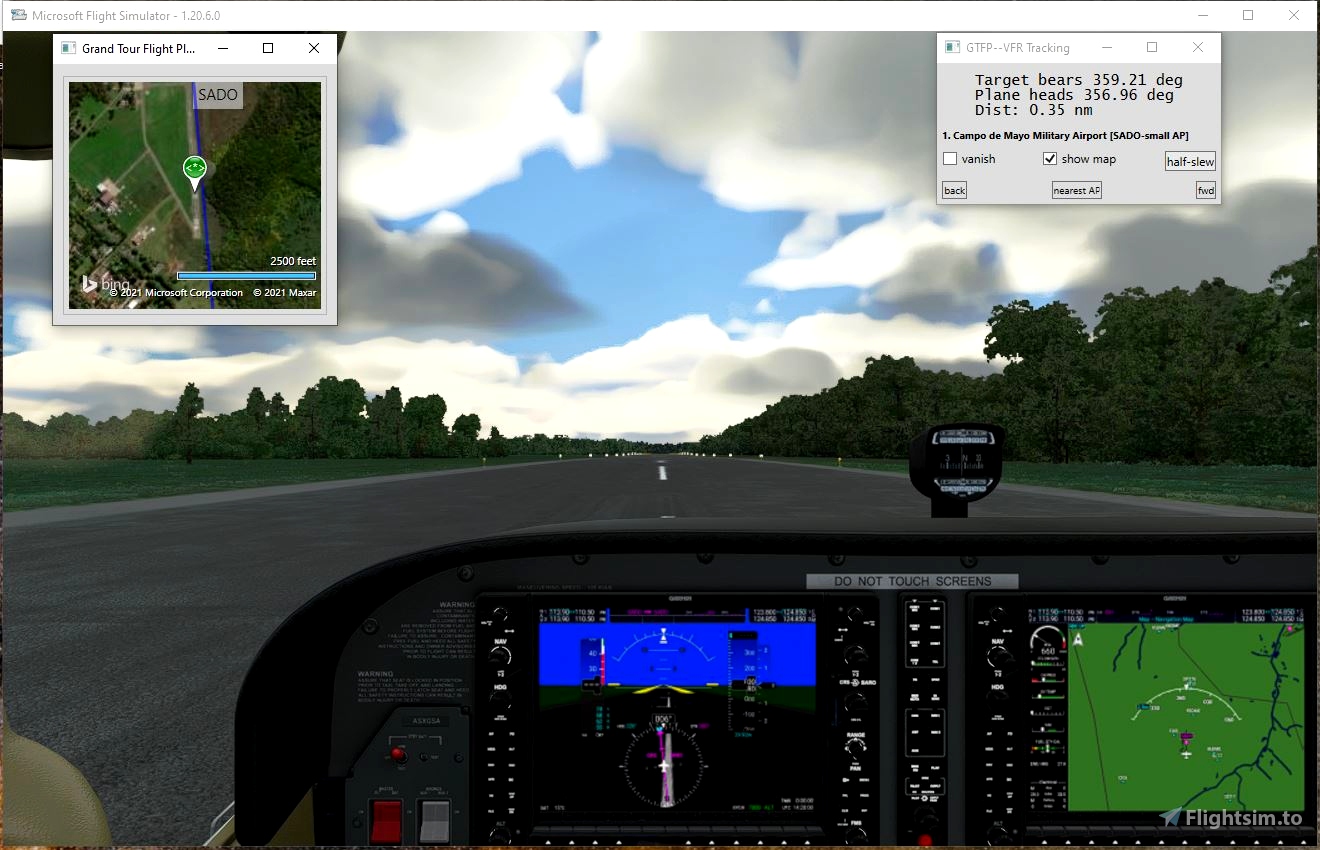
4. GTFP provides an easy way to navigate during VFR flight: It tracks the plane’s heading and the target’s bearing and distance together in a small window that can be overlaid on the main MSFS window. It allows you to slew to the next point in the route.
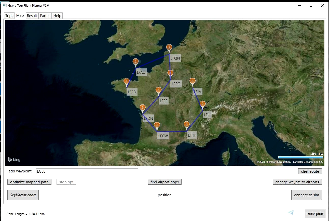
5. GTFP lets you overlay a small VFR map on top of MSFS where you can zoom in to great detail, or out to show as much of the world as you wish. It tracks your plane in real time. It has options to label political boundaries, show only roads, or show unlabeled geographic features (matching what you see from the cockpit).
A Users' Guide is available. Here is a quote from the FAQ that shows a way to use some of GTFP features.
-------
I want to fly over both my house and the Cleveland Museum of Rock and Roll. What do I do? Put your house address in the add waypoint box (on the Map page) and click enter key. When the waypoint is created, right click on it and then on “add nearest airport” button (or put a specific airport code in the add waypoint box). Set that airport to be both FIRST and LAST via right click on the airport map pin. Put “Cleveland Rock and Roll Museum" in the add waypoint box and click enter key. Now click on optimize mapped path button to make the shortest route. That should generate the flight plan you want.
------


7 days ago
Loopmee22
Robert
New Zealand.
14 days ago
NZ1159
Loaded into my Cessna 172 G1000 and was able to follow all waypoints in GPS NAV mode.
What a great route!
Please assume that the reason I was not able to make the original flight plans work was most likely pilot error.
4 months ago
jlguardado
6 months ago
opcartmell
9 months ago
Jamino68
This is a fantastic app. I started out cherry picking through the list and am now flying every plan presently on G. Visiting places I never would have imagined and seeing things that are truly amazing and this is just a game I keep telling myself. Thank you for putting this together and I look forward to updates with more wow factor flying.
1 years ago
ThelynxPA
Hi,
I am having a problem with the generated waypoints when I open up the PLN file in MSFS. They are showing up as the north pole instead of the waypoint plotted in the GT tool. Any idea why?
1 years ago
Thanks for the bug report. I am unable to duplicate this problem. Could you email me what you did to create the flight plan that caused the problem and include the steps you did in GTFP so that I can try and duplicate it. My email address is in the User's Guide at the end.
On 2/28 I downloaded your GTFP- FP into MSFS. It seems to work now: the MSFS chart and navaid waypoint (distance and direction) all conform to GTFP's generation.
Please ensure you have the latest MSFS patches and try again. If the problem persists, let me know and I will look further. PS: I note that there was a similar complaint about LittleNavMap generated FP's, but have heard of no follow-up.
According to the original poster (3/1), this was a bug elsewhere and is now cleared up.
1 years ago
fredm73
occupancy.moist7
10.3 runs w/o any "special" setup. This is truly a Great Program! Use it all the time to setup NeoFly "stacked missions". Does not seem to be the case for 10.4 (no setup instructions). I seem to be missing something.
1 years ago
Could you be more specific? I did not change anything (that I know of) that would affect setup. If I can duplicate the problem I will seek a solution. If you wish, email me with as much detail as possible. My address is in the User's Guide, p.17, , in the Help tab.
1 years ago
fredm73
LarryFS2020
Looks great. Can I use this stand-alone or does MSFS have to be running?
2 years ago
You can use GTFP alone, without MSFS running or even installed on your computer
2 years ago
fredm73
Hawker
A wonderful piece of Software. Elegant is also how I would describe it. So much software these days tends to be 'clumsily' executed.
I would however ask for one additional change: instead of only copying the Result to the clipboard, could you add a print option to the default printer. A screendump would do it in landscape. No additional info required. It would be an additional way of flying without importing the plan into MSFS but also avoiding all the faffing around needing to import the clipboard into Notepad or something. Purely flying on bearings from paper would also be fun.
Thank you.
2 years ago
Thanks for the suggestion and the compliment.
I will think about this improvement.
However, printing in .NET Core adds significant memory requirements to the downloaded application and about 150 lines of code to do it properly.
2 years ago
fredm73
cusance
Downloaded this a couple of weeks ago. Loving it. Makes flight planning nice and simple. Love the info it gives for your route. Thank you for such a great little program.
2 years ago
Enigmaau
Hi Fred,
Haven't talked in a while.
Just downloaded the 10.2 version and I believe this issue is back. From discussion 6 months ago comment:
There is this bug in GTFP: the folder name was saved when you *saved* an FP, but not when you *loaded* an FP. I will change the logic to save the folder name you select on *both* events in the next version of GTFP. (Note that only one folder name is going to be saved by GTFP, and that MSFS does *not* save the folder name you load/save an FP to). The fix to GTFP will be out in a week or so.
I'm not sure if this is the problem you are seeing. If not, I need further information from you so as to duplicate your bug. Anyway, thanks for the bug report!
2 years ago
Thanks for the bug report. It should be fixed in the latest version, V10.3, now uploaded.
2 years ago
fredm73
kklosterman
Hi 😊 I want to make a world tour. Saving a flight is not an option, when I reload a flight I can't change the weather or time of day anymore. What would be the best way to use a huge flightplan - Each time I start flying, delete the legs I did in my previous flight and save that plan? or would there be a more convenient way?
2 years ago
Your strategy is what I follow, except after I finish some legs and wish to quit, I use GTFP to delete the waypoints I have visited and save the FP. I load that into MSFS and GTFP the next time I fly.
I am currently visiting every country in the GTFP plan for that. I am also using the "half-slew" when things get boring.
2 years ago
fredm73
Warrie
I may have missed it but is there a way to control-select more than one item in a list? ie more than one country?
2 years ago
That is not possible. Where you thinking this would be a way to combine multiple plans into one flight plan?
2 years ago
fredm73
CptMoustache
I would like to insert waypoints, using GPS coordinates. How is it possible?
2 years ago
Just enter the (lat, lon) in the 'add waypoint" box on the Map page: e.g. (48.858, 2.294). Full information on this box is in the User's Guide, accessible from the 'help' tab.
2 years ago
fredm73
Nounours06